Certaldo night lights from space
Night Light of Certaldo (Tuscany) from space (Italy) Src. Average luminocity for 10x10km area is 15.6873% and for 50x50km: 16.5763%.
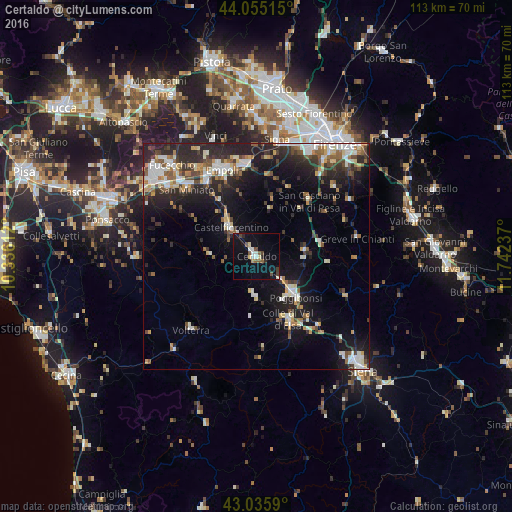
Analysis of Certaldo night lights 2016
Square area 10x10 km:
 1.59%
1.59%90-99
2.54%80-89
1.9%70-79
0.63%60-69
0%50-59
3.33%40-49
3.49%30-39
0.79%20-29
1.9%10-19
10.63%0-9
73.17%Square area 50x50 km:
2.45%90-99
3.16%80-89
1.57%70-79
1.47%60-69
1.68%50-59
1.99%40-49
2.51%30-39
2.41%20-29
6.52%10-19
11.03%0-9
65.22%Clear (daylight) street map image can be seen on geolist.org.
Map coordinates:
44° 3' 18.5" North, 10° 20' 10" East
43° 32' 51.6" North, 11° 2' 21.3" East
43° 2' 9.2" North, 11° 44' 32.5" East
Some cities around Certaldo sort by population:
• Empoli
20.3 km =12.6 mi,  338°
338°
• Poggibonsi
12.3 km =7.6 mi,  134°
134°
• San Miniato
21.2 km =13.2 mi,  313°
313°
• Colle di Val d'Elsa
15.8 km =9.8 mi,  153°
153°
• Castelfiorentino
9 km =5.6 mi,  320°
320°
• Montelupo Fiorentino
20.4 km =12.7 mi,  353°
353°
• Tavarnelle Val di Pesa
10.8 km =6.7 mi,  81°
81°
• San Casciano in Val di Pesa
17.1 km =10.6 mi,  43°
43°
3179024 (p: 12,981)
Sources (retrieved 2019-11-25):
» Earth at Night: Flat Maps 2012, 2016