Ozzano dell'Emilia night lights from space
Night Light of Ozzano dell'Emilia (Emilia-Romagna) from space (Italy) Src. Average luminocity for 10x10km area is 39.0984% and for 50x50km: 22.7132%.
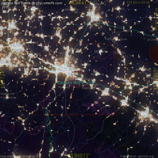
Analysis of Ozzano dell'Emilia night lights 2016
Square area 10x10 km:
 4.29%
4.29%90-99
10.95%80-89
2.22%70-79
4.6%60-69
4.13%50-59
5.08%40-49
4.76%30-39
6.03%20-29
17.14%10-19
35.24%0-9
5.56%Square area 50x50 km:
4.3%90-99
4.88%80-89
1.78%70-79
1.75%60-69
2.31%50-59
2.73%40-49
2.71%30-39
3.59%20-29
6.97%10-19
17.81%0-9
51.18%Clear (daylight) street map image can be seen on geolist.org.
Map coordinates:
44° 56' 38.8" North, 10° 46' 20.6" East
44° 26' 39.4" North, 11° 28' 31.9" East
43° 56' 24.5" North, 12° 10' 43.1" East
Some cities around Ozzano dell'Emilia sort by population:
• Bologna
12.2 km =7.6 mi,  296°
296°
• San Lazzaro
6.1 km =3.8 mi, 298°
• Castel San Pietro Terme
10.1 km =6.3 mi,  120°
120°
• Castenaso
7.8 km =4.8 mi,  355°
355°
• Budrio
11.4 km =7.1 mi,  24°
24°
• Pianoro
12.2 km =7.6 mi,  239°
239°
• Granarolo dell'Emilia e Viadagola
12.4 km =7.7 mi,  347°
347°
• Rastignano-Carteria di Sesto
9.5 km =5.9 mi,  264°
264°
6534261 (p: 8,825)
Sources (retrieved 2019-11-25):
» Earth at Night: Flat Maps 2012, 2016