Castenaso night lights from space
Night Light of Castenaso (Emilia-Romagna) from space (Italy) Src. Average luminocity for 10x10km area is 50.0159% and for 50x50km: 24.3356%.
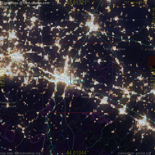
Analysis of Castenaso night lights 2016
Square area 10x10 km:
 10.63%
90-99
12.06%80-89
6.51%70-79
2.22%60-69
2.54%50-59
7.46%40-49
9.21%30-39
10%20-29
14.92%10-19
23.97%0-9
0.48%Square area 50x50 km:
4.44%90-99
5.09%80-89
1.88%70-79
2%60-69
2.38%50-59
2.77%40-49
2.96%30-39
3.69%20-29
7.33%10-19
21.7%0-9
45.74%Clear (daylight) street map image can be seen on geolist.org.
Map coordinates:
45° 0' 47.6" North, 10° 45' 55.1" East
44° 30' 50.3" North, 11° 28' 6.3" East
44° 0' 37.6" North, 12° 10' 17.6" East
Some cities around Castenaso sort by population:
• Bologna
10.5 km =6.5 mi,  257°
257°
• San Lazzaro
6.8 km =4.2 mi,  224°
224°
• Progresso
10.3 km =6.4 mi,  306°
306°
• Budrio
5.8 km =3.6 mi,  63°
63°
• Ozzano dell'Emilia
7.8 km =4.8 mi,  175°
175°
• Medicina-Buda
14 km =8.7 mi,  106°
106°
• Granarolo dell'Emilia e Viadagola
4.8 km =3 mi,  335°
335°
• Rastignano-Carteria di Sesto
12.4 km =7.7 mi,  225°
225°
3179441 (p: 8,961)
Sources (retrieved 2019-11-25):
» Earth at Night: Flat Maps 2012, 2016