Budrio night lights from space
Night Light of Budrio (Emilia-Romagna) from space (Italy) Src. Average luminocity for 10x10km area is 18.8778% and for 50x50km: 24.4495%.
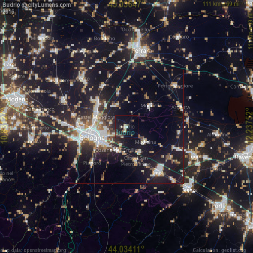
Analysis of Budrio night lights 2016
Square area 10x10 km:
 1.27%
1.27%90-99
2.7%80-89
3.33%70-79
0.95%60-69
1.11%50-59
2.06%40-49
3.17%30-39
1.43%20-29
5.4%10-19
28.41%0-9
50.16%Square area 50x50 km:
4.39%90-99
5.08%80-89
1.92%70-79
2.17%60-69
2.57%50-59
2.58%40-49
2.73%30-39
3.39%20-29
6.48%10-19
23.17%0-9
45.52%Clear (daylight) street map image can be seen on geolist.org.
Map coordinates:
45° 2' 11.3" North, 10° 49' 52.6" East
44° 32' 14.8" North, 11° 32' 3.8" East
44° 2' 2.8" North, 12° 14' 15.1" East
Some cities around Budrio sort by population:
• San Lazzaro
12.5 km =7.8 mi,  233°
233°
• Castel Maggiore
14.4 km =8.9 mi,  287°
287°
• Progresso
13.9 km =8.6 mi,  284°
284°
• Molinella
13.8 km =8.6 mi,  49°
49°
• Castenaso
5.8 km =3.6 mi,  243°
243°
• Ozzano dell'Emilia
11.4 km =7.1 mi,  204°
204°
• Medicina-Buda
10.5 km =6.5 mi,  128°
128°
• Granarolo dell'Emilia e Viadagola
7.5 km =4.7 mi, 283°
3181443 (p: 8,941)
Sources (retrieved 2019-11-25):
» Earth at Night: Flat Maps 2012, 2016