Rastignano-Carteria di Sesto night lights from space
Night Light of Rastignano-Carteria di Sesto (Emilia-Romagna) from space (Italy) Src. Average luminocity for 10x10km area is 39.3746% and for 50x50km: 22.9362%.
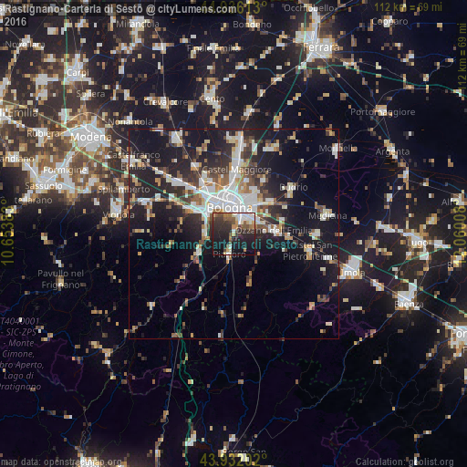
Analysis of Rastignano-Carteria di Sesto night lights 2016
Square area 10x10 km:
 6.35%
6.35%90-99
6.83%80-89
2.38%70-79
3.33%60-69
5.08%50-59
5.87%40-49
5.87%30-39
10.63%20-29
19.21%10-19
28.73%0-9
5.71%Square area 50x50 km:
4.1%90-99
4.85%80-89
1.89%70-79
1.96%60-69
2.24%50-59
2.69%40-49
2.95%30-39
3.81%20-29
7.87%10-19
18.24%0-9
49.4%Clear (daylight) street map image can be seen on geolist.org.
Map coordinates:
44° 56' 10.1" North, 10° 39' 13.8" East
44° 26' 10.4" North, 11° 21' 25" East
43° 55' 55.3" North, 12° 3' 36.3" East
Some cities around Rastignano-Carteria di Sesto sort by population:
• Bologna
6.6 km =4.1 mi,  347°
347°
• Casalecchio di Reno
7.8 km =4.8 mi,  303°
303°
• San Lazzaro
5.6 km =3.5 mi,  47°
47°
• Zola Predosa
12.5 km =7.8 mi, 298°
• Castenaso
12.4 km =7.7 mi, 45°
• Ozzano dell'Emilia
9.5 km =5.9 mi,  84°
84°
• Pianoro
5.4 km =3.4 mi,  192°
192°
• Sasso Marconi
9.2 km =5.7 mi,  244°
244°
6692061 (p: 5,231)
Sources (retrieved 2019-11-25):
» Earth at Night: Flat Maps 2012, 2016