Granarolo dell'Emilia e Viadagola night lights from space
Night Light of Granarolo dell'Emilia e Viadagola (Emilia-Romagna) from space (Italy) Src. Average luminocity for 10x10km area is 40.1794% and for 50x50km: 25.6644%.
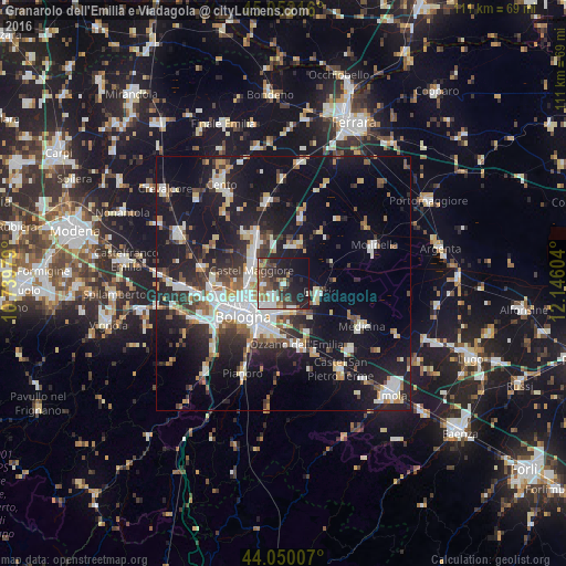
Analysis of Granarolo dell'Emilia e Viadagola night lights 2016
Square area 10x10 km:
 6.51%
6.51%90-99
6.19%80-89
2.86%70-79
1.27%60-69
7.14%50-59
7.46%40-49
8.25%30-39
10.79%20-29
16.35%10-19
26.98%0-9
6.19%Square area 50x50 km:
4.59%90-99
5.34%80-89
1.93%70-79
2.19%60-69
2.69%50-59
2.77%40-49
3.04%30-39
3.77%20-29
7.74%10-19
23.76%0-9
42.19%Clear (daylight) street map image can be seen on geolist.org.
Map coordinates:
45° 3' 7.8" North, 10° 44' 23.2" East
44° 33' 11.8" North, 11° 26' 34.5" East
44° 3' 0.3" North, 12° 8' 45.7" East
Some cities around Granarolo dell'Emilia e Viadagola sort by population:
• Bologna
10.6 km =6.6 mi,  231°
231°
• San Lazzaro
9.6 km =6 mi,  196°
196°
• Castel Maggiore
7 km =4.3 mi,  292°
292°
• Progresso
6.5 km =4 mi, 285°
• Castenaso
4.8 km =3 mi,  155°
155°
• Budrio
7.5 km =4.7 mi,  103°
103°
• Ozzano dell'Emilia
12.4 km =7.7 mi,  167°
167°
• San Giorgio di Piano
11.8 km =7.3 mi,  332°
332°
3163830 (p: 5,633)
Sources (retrieved 2019-11-25):
» Earth at Night: Flat Maps 2012, 2016