Castel San Pietro Terme night lights from space
Night Light of Castel San Pietro Terme (Emilia-Romagna) from space (Italy) Src. Average luminocity for 10x10km area is 23.9079% and for 50x50km: 20.6824%.
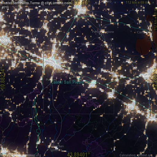
Analysis of Castel San Pietro Terme night lights 2016
Square area 10x10 km:
 2.86%
2.86%90-99
5.56%80-89
1.11%70-79
4.6%60-69
1.75%50-59
2.06%40-49
0.48%30-39
2.54%20-29
2.7%10-19
47.3%0-9
29.05%Square area 50x50 km:
4.09%90-99
4.53%80-89
1.41%70-79
1.68%60-69
2.15%50-59
2.16%40-49
2.4%30-39
2.77%20-29
5.82%10-19
18.45%0-9
54.55%Clear (daylight) street map image can be seen on geolist.org.
Map coordinates:
44° 53' 55.5" North, 10° 52' 56.4" East
44° 23' 54.7" North, 11° 35' 7.7" East
43° 53' 38.4" North, 12° 17' 18.9" East
Some cities around Castel San Pietro Terme sort by population:
• Imola
11.1 km =6.9 mi,  113°
113°
• San Lazzaro
16.2 km =10.1 mi,  299°
299°
• Massa Lombarda
19.5 km =12.1 mi,  73°
73°
• Budrio
16 km =9.9 mi,  345°
345°
• Ozzano dell'Emilia
10.1 km =6.3 mi, 300°
• Medicina-Buda
9.8 km =6.1 mi,  25°
25°
• Pianoro
19.3 km =12 mi,  266°
266°
• Rastignano-Carteria di Sesto
18.6 km =11.6 mi,  283°
283°
3179479 (p: 11,081)
Sources (retrieved 2019-11-25):
» Earth at Night: Flat Maps 2012, 2016