Osio Sotto night lights from space
Night Light of Osio Sotto (Lombardy) from space (Italy) Src. Average luminocity for 10x10km area is 86.0742% and for 50x50km: 59.1254%.
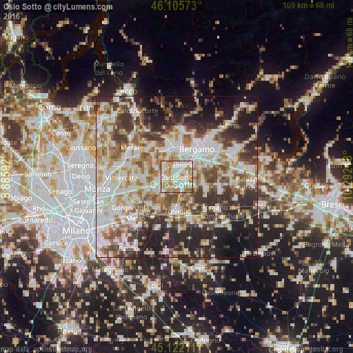
Analysis of Osio Sotto night lights 2016
Square area 10x10 km:
 27.42%
90-99
27.73%80-89
8.18%70-79
15.15%60-69
18.18%50-59
2.88%40-49
0.45%30-39
0%20-29
0%10-19
0%0-9
0%Square area 50x50 km:
14.19%90-99
14.75%80-89
5.77%70-79
7.06%60-69
8.38%50-59
7.83%40-49
7.26%30-39
8.48%20-29
12.05%10-19
11.23%0-9
3%Clear (daylight) street map image can be seen on geolist.org.
Map coordinates:
46° 6' 20.6" North, 8° 53' 9.3" East
45° 36' 57.9" North, 9° 35' 20.6" East
45° 7' 19.6" North, 10° 17' 31.8" East
Some cities around Osio Sotto sort by population:
• Dalmine
3.9 km =2.4 mi,  19°
19°
• Trezzo sull'Adda
5.9 km =3.7 mi,  258°
258°
• Capriate San Gervasio
4.6 km =2.9 mi,  265°
265°
• Verdellino
2.2 km =1.4 mi,  138°
138°
• Verdello
3.4 km =2.1 mi,  114°
114°
• Brembate
3 km =1.9 mi,  244°
244°
• Ciserano
3.3 km =2.1 mi,  163°
163°
• Boltiere
1.9 km =1.2 mi,  206°
206°
6534213 (p: 11,181)
Sources (retrieved 2019-11-25):
» Earth at Night: Flat Maps 2012, 2016