Trezzo sull'Adda night lights from space
Night Light of Trezzo sull'Adda (Lombardy) from space (Italy) Src. Average luminocity for 10x10km area is 82.4318% and for 50x50km: 65.0662%.
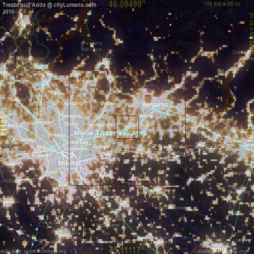
Analysis of Trezzo sull'Adda night lights 2016
Square area 10x10 km:
 19.55%
90-99
26.97%80-89
7.27%70-79
18.33%60-69
20.61%50-59
4.85%40-49
2.42%30-39
0%20-29
0%10-19
0%0-9
0%Square area 50x50 km:
20.07%90-99
15.54%80-89
6.16%70-79
7.71%60-69
8.77%50-59
7.19%40-49
6.7%30-39
7.76%20-29
10.29%10-19
7.94%0-9
1.87%Clear (daylight) street map image can be seen on geolist.org.
Map coordinates:
46° 5' 41.9" North, 8° 48' 39.8" East
45° 36' 18.8" North, 9° 30' 51" East
45° 6' 40.2" North, 10° 13' 2.3" East
Some cities around Trezzo sull'Adda sort by population:
• Cornate d'Adda
4 km =2.5 mi,  309°
309°
• Vaprio d'Adda
3.3 km =2.1 mi,  166°
166°
• Capriate San Gervasio
1.5 km =0.9 mi,  55°
55°
• Fara Gera d'Adda
5.7 km =3.5 mi,  162°
162°
• Brembate
3.2 km =2 mi,  91°
91°
• Busnago
4.1 km =2.5 mi,  287°
287°
• Boltiere
5 km =3.1 mi,  95°
95°
• Bottanuco
3.8 km =2.4 mi,  353°
353°
3165197 (p: 11,782)
Sources (retrieved 2019-11-25):
» Earth at Night: Flat Maps 2012, 2016