Capriate San Gervasio night lights from space
Night Light of Capriate San Gervasio (Lombardy) from space (Italy) Src. Average luminocity for 10x10km area is 83.2288% and for 50x50km: 63.8624%.
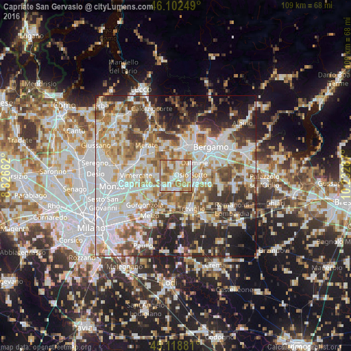
Analysis of Capriate San Gervasio night lights 2016
Square area 10x10 km:
 21.21%
90-99
26.67%80-89
6.67%70-79
18.48%60-69
22.12%50-59
3.94%40-49
0.91%30-39
0%20-29
0%10-19
0%0-9
0%Square area 50x50 km:
18.93%90-99
15.44%80-89
6.09%70-79
7.64%60-69
8.74%50-59
7.16%40-49
6.84%30-39
7.75%20-29
10.48%10-19
8.25%0-9
2.68%Clear (daylight) street map image can be seen on geolist.org.
Map coordinates:
46° 6' 9" North, 8° 49' 35.8" East
45° 36' 46.1" North, 9° 31' 47.1" East
45° 7' 7.7" North, 10° 13' 58.3" East
Some cities around Capriate San Gervasio sort by population:
• Trezzo sull'Adda
1.5 km =0.9 mi,  235°
235°
• Osio Sotto
4.6 km =2.9 mi,  85°
85°
• Cornate d'Adda
4.7 km =2.9 mi,  291°
291°
• Vaprio d'Adda
4.1 km =2.5 mi,  186°
186°
• Brembate
2.1 km =1.3 mi,  114°
114°
• Busnago
5.1 km =3.2 mi,  274°
274°
• Boltiere
4 km =2.5 mi, 109°
• Bottanuco
3.4 km =2.1 mi,  331°
331°
3180626 (p: 7,714)
Sources (retrieved 2019-11-25):
» Earth at Night: Flat Maps 2012, 2016