Boltiere night lights from space
Night Light of Boltiere (Lombardy) from space (Italy) Src. Average luminocity for 10x10km area is 83.9652% and for 50x50km: 60.4744%.
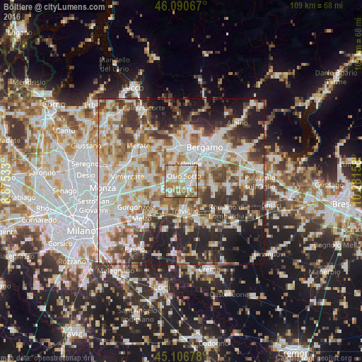
Analysis of Boltiere night lights 2016
Square area 10x10 km:
 25.3%
25.3%90-99
26.36%80-89
8.03%70-79
15%60-69
18.03%50-59
4.24%40-49
3.03%30-39
0%20-29
0%10-19
0%0-9
0%Square area 50x50 km:
15.14%90-99
15%80-89
5.9%70-79
7.31%60-69
8.5%50-59
7.76%40-49
7.25%30-39
8.41%20-29
11.89%10-19
10.55%0-9
2.3%Clear (daylight) street map image can be seen on geolist.org.
Map coordinates:
46° 5' 26.4" North, 8° 52' 31.2" East
45° 36' 3.2" North, 9° 34' 42.4" East
45° 6' 24.4" North, 10° 16' 53.7" East
Some cities around Boltiere sort by population:
• Trezzo sull'Adda
5 km =3.1 mi,  275°
275°
• Osio Sotto
1.9 km =1.2 mi,  26°
26°
• Vaprio d'Adda
5 km =3.1 mi,  237°
237°
• Capriate San Gervasio
4 km =2.5 mi,  289°
289°
• Verdellino
2.3 km =1.4 mi,  89°
89°
• Verdello
3.9 km =2.4 mi, 85°
• Brembate
1.9 km =1.2 mi, 282°
• Ciserano
2.3 km =1.4 mi,  129°
129°
6534957 (p: 5,568)
Sources (retrieved 2019-11-25):
» Earth at Night: Flat Maps 2012, 2016