Mori night lights from space
Night Light of Mori (Trentino-Alto Adige) from space (Italy) Src. Average luminocity for 10x10km area is 21.369% and for 50x50km: 8.2087%.
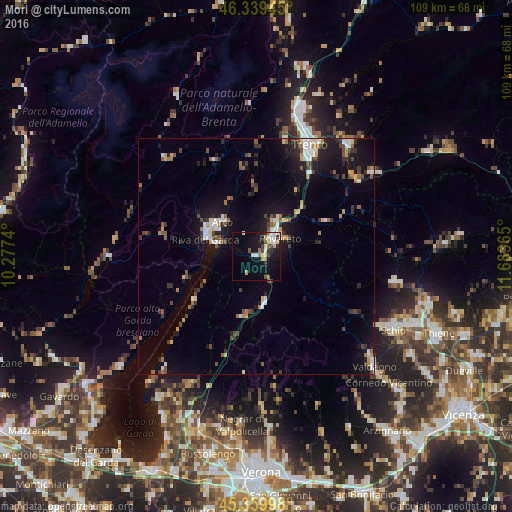
Analysis of Mori night lights 2016
Square area 10x10 km:
 2.98%
2.98%90-99
4.91%80-89
1.04%70-79
2.83%60-69
1.64%50-59
2.68%40-49
2.08%30-39
2.98%20-29
2.83%10-19
21.28%0-9
54.76%Square area 50x50 km:
0.92%90-99
1.3%80-89
0.6%70-79
0.84%60-69
0.81%50-59
1.11%40-49
1.13%30-39
1.33%20-29
1.89%10-19
7.66%0-9
82.42%Clear (daylight) street map image can be seen on geolist.org.
Map coordinates:
46° 20' 22" North, 10° 16' 38.6" East
45° 51' 6.7" North, 10° 58' 49.9" East
45° 21' 35.9" North, 11° 41' 1.1" East
Some cities around Mori sort by population:
• Trento
26.4 km =16.4 mi,  24°
24°
• Rovereto
6.3 km =3.9 mi,  47°
47°
• Riva del Garda
11.4 km =7.1 mi,  289°
289°
• Arco
10.3 km =6.4 mi,  315°
315°
• Pergine Valsugana
30.9 km =19.2 mi,  40°
40°
• Levico Terme
30.7 km =19.1 mi, 54°
• Ala
10.3 km =6.4 mi,  169°
169°
• Mattarello
20.9 km =13 mi,  33°
33°
3172598 (p: 7,660)
Sources (retrieved 2019-11-25):
» Earth at Night: Flat Maps 2012, 2016