Ala night lights from space
Night Light of Ala (Trentino-Alto Adige) from space (Italy) Src. Average luminocity for 10x10km area is 9.3651% and for 50x50km: 9.4127%.
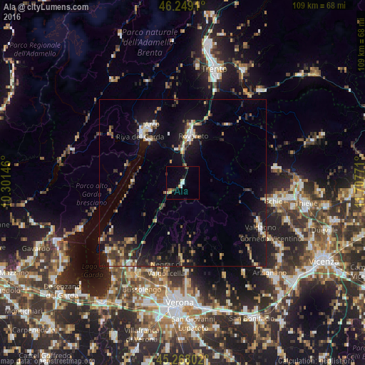
Analysis of Ala night lights 2016
Square area 10x10 km:
 1.27%
1.27%90-99
1.59%80-89
0.63%70-79
1.59%60-69
0.95%50-59
0.32%40-49
2.22%30-39
0.95%20-29
0.63%10-19
1.27%0-9
88.57%Square area 50x50 km:
0.69%90-99
1.27%80-89
0.95%70-79
0.92%60-69
1.04%50-59
1.13%40-49
1.63%30-39
1.89%20-29
2.78%10-19
9.64%0-9
78.06%Clear (daylight) street map image can be seen on geolist.org.
Map coordinates:
46° 14' 56.8" North, 10° 18' 5.3" East
45° 45' 38.6" North, 11° 0' 16.5" East
45° 16' 4.9" North, 11° 42' 27.8" East
Some cities around Ala sort by population:
• Rovereto
14.7 km =9.1 mi,  10°
10°
• Schio
27.8 km =17.3 mi,  101°
101°
• Valdagno
26.2 km =16.3 mi,  119°
119°
• Riva del Garda
18.8 km =11.7 mi,  317°
317°
• Arco
19.7 km =12.2 mi,  332°
332°
• Mori
10.3 km =6.4 mi,  349°
349°
• Negrar
26.2 km =16.3 mi,  191°
191°
• San Pietro in Cariano
28.6 km =17.8 mi,  198°
198°
3183374 (p: 5,331)
Sources (retrieved 2019-11-25):
» Earth at Night: Flat Maps 2012, 2016