Riva del Garda night lights from space
Night Light of Riva del Garda (Trentino-Alto Adige) from space (Italy) Src. Average luminocity for 10x10km area is 26.808% and for 50x50km: 7.7985%.
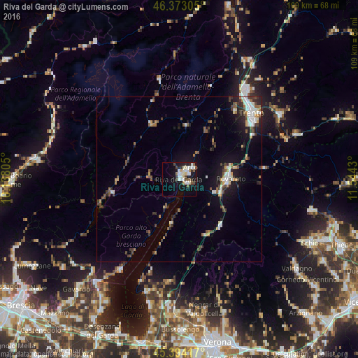
Analysis of Riva del Garda night lights 2016
Square area 10x10 km:
 5.36%
5.36%90-99
7.44%80-89
3.27%70-79
0.74%60-69
1.64%50-59
2.83%40-49
3.42%30-39
1.79%20-29
4.46%10-19
25.15%0-9
43.9%Square area 50x50 km:
0.99%90-99
1.35%80-89
0.54%70-79
0.74%60-69
0.79%50-59
1.18%40-49
1.18%30-39
1.31%20-29
1.93%10-19
5.44%0-9
84.55%Clear (daylight) street map image can be seen on geolist.org.
Map coordinates:
46° 22' 23" North, 10° 8' 17" East
45° 53' 8.8" North, 10° 50' 28.2" East
45° 23' 39" North, 11° 32' 39.5" East
Some cities around Riva del Garda sort by population:
• Trento
29.6 km =18.4 mi,  46°
46°
• Rovereto
15.4 km =9.6 mi,  88°
88°
• Arco
5 km =3.1 mi,  44°
44°
• Mori
11.4 km =7.1 mi,  109°
109°
• Toscolano Maderno
32.8 km =20.4 mi,  213°
213°
• Lavis
35.2 km =21.9 mi, 36°
• Ala
18.8 km =11.7 mi,  137°
137°
• Mattarello
26.2 km =16.3 mi,  58°
58°
3169272 (p: 14,727)
Sources (retrieved 2019-11-25):
» Earth at Night: Flat Maps 2012, 2016