San Michele night lights from space
Night Light of San Michele (Trentino-Alto Adige) from space (Italy) Src. Average luminocity for 10x10km area is 13.8423% and for 50x50km: 5.6574%.
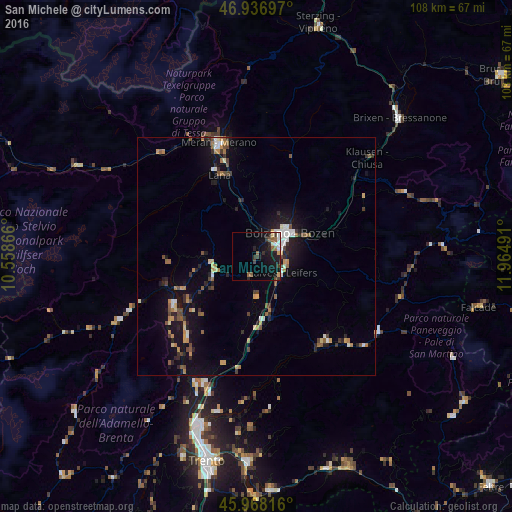
Analysis of San Michele night lights 2016
Square area 10x10 km:
 1.79%
1.79%90-99
1.79%80-89
0.45%70-79
1.34%60-69
1.49%50-59
2.98%40-49
1.04%30-39
3.42%20-29
4.17%10-19
16.82%0-9
64.73%Square area 50x50 km:
0.52%90-99
0.68%80-89
0.42%70-79
0.79%60-69
0.78%50-59
0.85%40-49
0.79%30-39
0.76%20-29
1.4%10-19
4.83%0-9
88.17%Clear (daylight) street map image can be seen on geolist.org.
Map coordinates:
46° 56' 13.1" North, 10° 33' 31.2" East
46° 27' 17" North, 11° 15' 42.4" East
45° 58' 5.4" North, 11° 57' 53.7" East
Some cities around San Michele sort by population:
• Bolzano
7.2 km =4.5 mi,  56°
56°
• Merano
25 km =15.5 mi,  341°
341°
• Laives
6.6 km =4.1 mi,  117°
117°
• Lana
19.3 km =12 mi, 335°
• Renon - Ritten
17.8 km =11.1 mi, 57°
• Mezzolombardo
30.3 km =18.8 mi,  204°
204°
• Caldaro sulla Strada del Vino
4.8 km =3 mi,  194°
194°
• Cles
20.3 km =12.6 mi,  239°
239°
3182966 (p: 5,967)
Sources (retrieved 2019-11-25):
» Earth at Night: Flat Maps 2012, 2016