Manerbio night lights from space
Night Light of Manerbio (Lombardy) from space (Italy) Src. Average luminocity for 10x10km area is 37.019% and for 50x50km: 35.4946%.
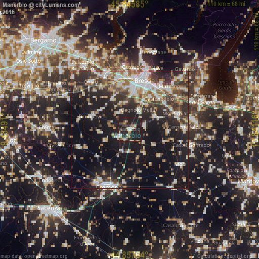
Analysis of Manerbio night lights 2016
Square area 10x10 km:
 3.97%
3.97%90-99
7.14%80-89
3.33%70-79
2.7%60-69
5.87%50-59
3.49%40-49
4.29%30-39
5.4%20-29
20.48%10-19
43.33%0-9
0%Square area 50x50 km:
5.99%90-99
7.02%80-89
2.96%70-79
3.18%60-69
4.57%50-59
4.84%40-49
4.95%30-39
6.48%20-29
11.4%10-19
27.53%0-9
21.09%Clear (daylight) street map image can be seen on geolist.org.
Map coordinates:
45° 50' 45.1" North, 9° 26' 5.7" East
45° 21' 14" North, 10° 8' 16.9" East
44° 51' 27.5" North, 10° 50' 28.2" East
Some cities around Manerbio sort by population:
• Ghedi
12.1 km =7.5 mi,  63°
63°
• Bagnolo Mella
9 km =5.6 mi,  24°
24°
• Leno
6.4 km =4 mi,  74°
74°
• Borgosatollo
15.8 km =9.8 mi,  30°
30°
• Flero
14.6 km =9.1 mi,  11°
11°
• Verolanuova
5.4 km =3.4 mi,  238°
238°
• Quinzano d'Oglio
11.1 km =6.9 mi,  246°
246°
• Pontevico
9.7 km =6 mi,  201°
201°
3174093 (p: 12,228)
Sources (retrieved 2019-11-25):
» Earth at Night: Flat Maps 2012, 2016