Flero night lights from space
Night Light of Flero (Lombardy) from space (Italy) Src. Average luminocity for 10x10km area is 72.5794% and for 50x50km: 41.3813%.
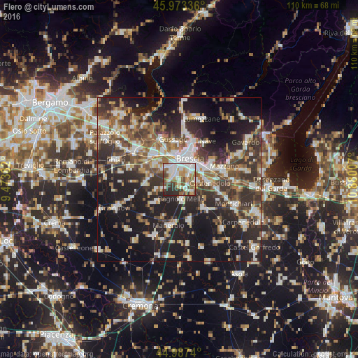
Analysis of Flero night lights 2016
Square area 10x10 km:
 20.95%
90-99
21.27%80-89
5.24%70-79
8.41%60-69
8.1%50-59
12.22%40-49
8.1%30-39
7.78%20-29
7.94%10-19
0%0-9
0%Square area 50x50 km:
6.96%90-99
8.07%80-89
3.59%70-79
4.12%60-69
5.36%50-59
6.69%40-49
6.49%30-39
8.93%20-29
13.68%10-19
24.45%0-9
11.67%Clear (daylight) street map image can be seen on geolist.org.
Map coordinates:
45° 58' 24.1" North, 9° 28' 25.8" East
45° 28' 57.1" North, 10° 10' 37" East
44° 59' 14.6" North, 10° 52' 48.3" East
Some cities around Flero sort by population:
• Brescia
6.6 km =4.1 mi,  26°
26°
• Travagliato
8.8 km =5.5 mi,  301°
301°
• Bagnolo Mella
6.1 km =3.8 mi,  173°
173°
• Castel Mella
3.1 km =1.9 mi,  306°
306°
• Roncadelle
5.3 km =3.3 mi,  340°
340°
• Borgosatollo
5 km =3.1 mi,  97°
97°
• Castenedolo
9 km =5.6 mi, 95°
• Torbole Casaglia
5.8 km =3.6 mi, 305°
3176907 (p: 7,389)
Sources (retrieved 2019-11-25):
» Earth at Night: Flat Maps 2012, 2016