Ghedi night lights from space
Night Light of Ghedi (Lombardy) from space (Italy) Src. Average luminocity for 10x10km area is 34.8476% and for 50x50km: 40.5333%.
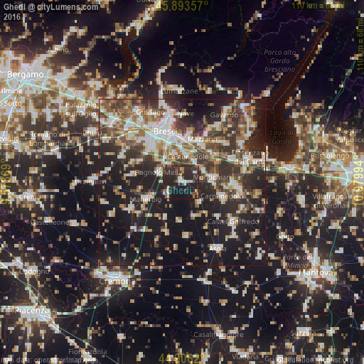
Analysis of Ghedi night lights 2016
Square area 10x10 km:
 4.29%
4.29%90-99
5.24%80-89
3.17%70-79
1.59%60-69
2.22%50-59
3.65%40-49
4.29%30-39
11.27%20-29
34.76%10-19
29.52%0-9
0%Square area 50x50 km:
6.53%90-99
7.91%80-89
3.43%70-79
3.93%60-69
5.33%50-59
6.35%40-49
6.58%30-39
8.39%20-29
13.31%10-19
28.3%0-9
9.92%Clear (daylight) street map image can be seen on geolist.org.
Map coordinates:
45° 53' 36.9" North, 9° 34' 25.3" East
45° 24' 7.3" North, 10° 16' 36.5" East
44° 54' 22.3" North, 10° 58' 47.8" East
Some cities around Ghedi sort by population:
• Montichiari
9.5 km =5.9 mi,  82°
82°
• Bagnolo Mella
7.6 km =4.7 mi,  291°
291°
• Leno
5.9 km =3.7 mi,  232°
232°
• Calcinato
12 km =7.5 mi,  59°
59°
• Borgosatollo
8.8 km =5.5 mi,  341°
341°
• Molinetto
12.1 km =7.5 mi,  32°
32°
• Castenedolo
8.1 km =5 mi,  8°
8°
• Flero
11.9 km =7.4 mi,  318°
318°
3176177 (p: 16,351)
Sources (retrieved 2019-11-25):
» Earth at Night: Flat Maps 2012, 2016