Verolanuova night lights from space
Night Light of Verolanuova (Lombardy) from space (Italy) Src. Average luminocity for 10x10km area is 33.3667% and for 50x50km: 32.0467%.
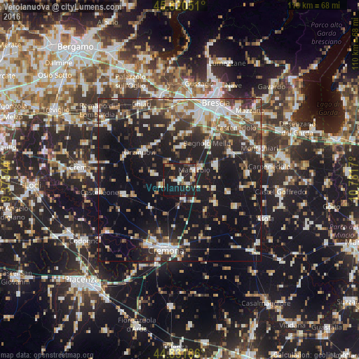
Analysis of Verolanuova night lights 2016
Square area 10x10 km:
 3.65%
3.65%90-99
6.35%80-89
3.02%70-79
1.9%60-69
6.03%50-59
2.54%40-49
3.33%30-39
3.81%20-29
16.83%10-19
49.37%0-9
3.17%Square area 50x50 km:
4.98%90-99
6.17%80-89
2.72%70-79
2.81%60-69
3.94%50-59
4.28%40-49
4.33%30-39
5.57%20-29
10.48%10-19
27.96%0-9
26.76%Clear (daylight) street map image can be seen on geolist.org.
Map coordinates:
45° 49' 13.8" North, 9° 22' 31.6" East
45° 19' 42" North, 10° 4' 42.9" East
44° 49' 54.7" North, 10° 46' 54.1" East
Some cities around Verolanuova sort by population:
• Ghedi
17.5 km =10.9 mi,  62°
62°
• Manerbio
5.4 km =3.4 mi, 58°
• Bagnolo Mella
13.9 km =8.6 mi,  37°
37°
• Leno
11.7 km =7.3 mi,  67°
67°
• Orzinuovi
14.6 km =9.1 mi,  303°
303°
• Quinzano d'Oglio
5.7 km =3.5 mi,  254°
254°
• Pontevico
6.2 km =3.9 mi,  169°
169°
• Trenzano
17.4 km =10.8 mi,  342°
342°
3164531 (p: 6,714)
Sources (retrieved 2019-11-25):
» Earth at Night: Flat Maps 2012, 2016