Bagnolo Mella night lights from space
Night Light of Bagnolo Mella (Lombardy) from space (Italy) Src. Average luminocity for 10x10km area is 39.8238% and for 50x50km: 40.9031%.
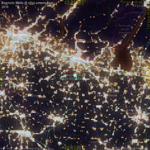
Analysis of Bagnolo Mella night lights 2016
Square area 10x10 km:
 5.56%
5.56%90-99
5.87%80-89
3.97%70-79
3.97%60-69
2.22%50-59
5.87%40-49
5.24%30-39
9.68%20-29
33.17%10-19
24.44%0-9
0%Square area 50x50 km:
6.88%90-99
8.17%80-89
3.57%70-79
4.04%60-69
5.16%50-59
6.48%40-49
6.37%30-39
8.76%20-29
12.79%10-19
24.98%0-9
12.79%Clear (daylight) street map image can be seen on geolist.org.
Map coordinates:
45° 55' 8.2" North, 9° 28' 59.7" East
45° 25' 39.5" North, 10° 11' 11" East
44° 55' 55.3" North, 10° 53' 22.2" East
Some cities around Bagnolo Mella sort by population:
• Ghedi
7.6 km =4.7 mi,  111°
111°
• Manerbio
9 km =5.6 mi,  204°
204°
• Castel Mella
8.6 km =5.3 mi,  338°
338°
• Leno
6.9 km =4.3 mi,  159°
159°
• Borgosatollo
6.9 km =4.3 mi,  37°
37°
• Castenedolo
9.7 km =6 mi,  57°
57°
• Flero
6.1 km =3.8 mi,  353°
353°
• Torbole Casaglia
10.9 km =6.8 mi,  330°
330°
3182500 (p: 11,871)
Sources (retrieved 2019-11-25):
» Earth at Night: Flat Maps 2012, 2016