Pontevico night lights from space
Night Light of Pontevico (Lombardy) from space (Italy) Src. Average luminocity for 10x10km area is 22.0106% and for 50x50km: 26.1705%.
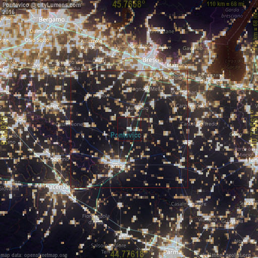
Analysis of Pontevico night lights 2016
Square area 10x10 km:
 3.03%
3.03%90-99
3.33%80-89
0.61%70-79
0.91%60-69
1.82%50-59
2.42%40-49
1.67%30-39
3.79%20-29
5.45%10-19
50.91%0-9
26.06%Square area 50x50 km:
3.11%90-99
4.41%80-89
2.13%70-79
2.44%60-69
3.19%50-59
3.14%40-49
3.25%30-39
4.75%20-29
9.09%10-19
30.87%0-9
33.62%Clear (daylight) street map image can be seen on geolist.org.
Map coordinates:
45° 45' 56.9" North, 9° 23' 21.7" East
45° 16' 23.3" North, 10° 5' 32.9" East
44° 46' 34.2" North, 10° 47' 44.2" East
Some cities around Pontevico sort by population:
• Cremona
16.5 km =10.3 mi,  199°
199°
• Manerbio
9.7 km =6 mi,  21°
21°
• Bagnolo Mella
18.7 km =11.6 mi, 23°
• Leno
14.4 km =8.9 mi,  42°
42°
• Orzinuovi
19.5 km =12.1 mi,  317°
317°
• Soresina
18.4 km =11.4 mi,  275°
275°
• Verolanuova
6.2 km =3.9 mi,  349°
349°
• Quinzano d'Oglio
8 km =5 mi,  304°
304°
3170208 (p: 5,714)
Sources (retrieved 2019-11-25):
» Earth at Night: Flat Maps 2012, 2016