Borgosatollo night lights from space
Night Light of Borgosatollo (Lombardy) from space (Italy) Src. Average luminocity for 10x10km area is 69.6444% and for 50x50km: 42.221%.
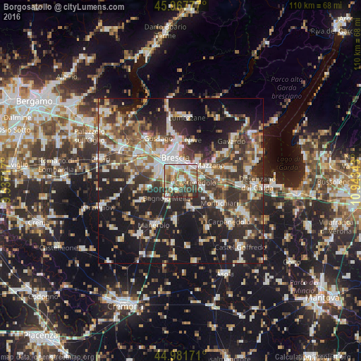
Analysis of Borgosatollo night lights 2016
Square area 10x10 km:
 16.19%
90-99
18.1%80-89
5.24%70-79
9.84%60-69
11.43%50-59
12.7%40-49
11.43%30-39
9.21%20-29
5.87%10-19
0%0-9
0%Square area 50x50 km:
7.1%90-99
8.17%80-89
3.65%70-79
4.34%60-69
5.64%50-59
6.65%40-49
7.01%30-39
8.87%20-29
14.13%10-19
24.57%0-9
9.87%Clear (daylight) street map image can be seen on geolist.org.
Map coordinates:
45° 58' 4" North, 9° 32' 13.8" East
45° 28' 36.8" North, 10° 14' 25.1" East
44° 58' 54.2" North, 10° 56' 36.3" East
Some cities around Borgosatollo sort by population:
• Brescia
6.8 km =4.2 mi,  343°
343°
• Rezzato
7.1 km =4.4 mi,  57°
57°
• Bagnolo Mella
6.9 km =4.3 mi,  217°
217°
• Castel Mella
7.8 km =4.8 mi,  288°
288°
• Botticino
8 km =5 mi,  43°
43°
• Roncadelle
8.7 km =5.4 mi,  309°
309°
• Castenedolo
4 km =2.5 mi,  94°
94°
• Flero
5 km =3.1 mi,  277°
277°
3181750 (p: 8,455)
Sources (retrieved 2019-11-25):
» Earth at Night: Flat Maps 2012, 2016