San Donnino night lights from space
Night Light of San Donnino (Tuscany) from space (Italy) Src. Average luminocity for 10x10km area is 82.7061% and for 50x50km: 27.6083%.
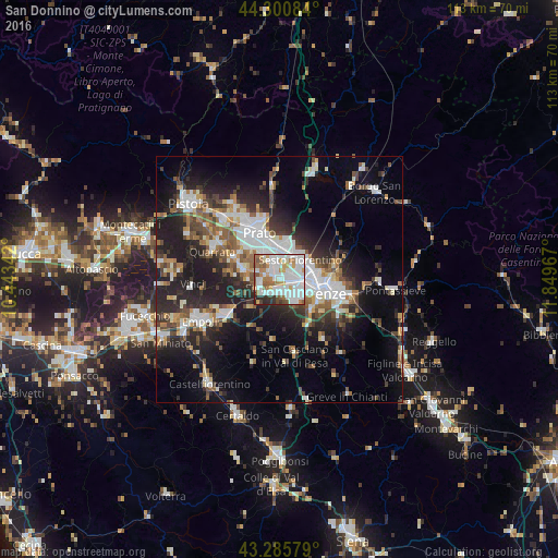
Analysis of San Donnino night lights 2016
Square area 10x10 km:
 33.33%
90-99
27.42%80-89
2.73%70-79
8.03%60-69
10%50-59
7.27%40-49
3.64%30-39
2.42%20-29
5.15%10-19
0%0-9
0%Square area 50x50 km:
5.69%90-99
5.52%80-89
2%70-79
2.3%60-69
3.17%50-59
3.99%40-49
4.08%30-39
3.59%20-29
9.2%10-19
14.77%0-9
45.7%Clear (daylight) street map image can be seen on geolist.org.
Map coordinates:
44° 18' 3" North, 10° 26' 36.3" East
43° 47' 43.7" North, 11° 8' 47.5" East
43° 17' 8.8" North, 11° 50' 58.8" East
Some cities around San Donnino sort by population:
• Florence
8.2 km =5.1 mi,  102°
102°
• Sesto Fiorentino
5.9 km =3.7 mi,  46°
46°
• Scandicci
5.7 km =3.5 mi,  144°
144°
• Campi Bisenzio
3.5 km =2.2 mi,  337°
337°
• Calenzano
6.7 km =4.2 mi,  13°
13°
• Signa
3.4 km =2.1 mi,  267°
267°
• Lastra a Signa
3.9 km =2.4 mi,  223°
223°
• Poggio A Caiano
7.9 km =4.9 mi,  285°
285°
8948774 (p: 5,772)
Sources (retrieved 2019-11-25):
» Earth at Night: Flat Maps 2012, 2016