Pontassieve night lights from space
Night Light of Pontassieve (Tuscany) from space (Italy) Src. Average luminocity for 10x10km area is 13.753% and for 50x50km: 15.3114%.
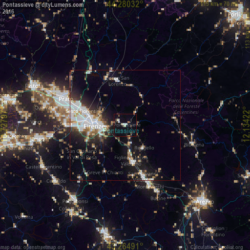
Analysis of Pontassieve night lights 2016
Square area 10x10 km:
 1.52%
1.52%90-99
1.97%80-89
1.67%70-79
0.3%60-69
0.91%50-59
0.61%40-49
2.42%30-39
1.36%20-29
2.73%10-19
5%0-9
81.52%Square area 50x50 km:
3.44%90-99
3.28%80-89
0.94%70-79
1.04%60-69
1.47%50-59
1.86%40-49
2.07%30-39
2.17%20-29
3.75%10-19
8.44%0-9
71.54%Clear (daylight) street map image can be seen on geolist.org.
Map coordinates:
44° 16' 49.2" North, 10° 43' 40.7" East
43° 46' 29.2" North, 11° 25' 51.9" East
43° 15' 53.7" North, 12° 8' 3.2" East
Some cities around Pontassieve sort by population:
• Florence
14.8 km =9.2 mi,  271°
271°
• Sesto Fiorentino
19.7 km =12.2 mi,  288°
288°
• Scandicci
19.7 km =12.2 mi,  263°
263°
• Figline Valdarno
17.5 km =10.9 mi,  169°
169°
• Borgo San Lorenzo
20.4 km =12.7 mi,  349°
349°
• Grassina Ponte a Ema
11.5 km =7.1 mi,  246°
246°
• San Donnino
23 km =14.3 mi,  275°
275°
• Bagno a Ripoli
9.1 km =5.7 mi, 253°
3170317 (p: 9,890)
Sources (retrieved 2019-11-25):
» Earth at Night: Flat Maps 2012, 2016