San Giorgio di Piano night lights from space
Night Light of San Giorgio di Piano (Emilia-Romagna) from space (Italy) Src. Average luminocity for 10x10km area is 39.2955% and for 50x50km: 30.3137%.
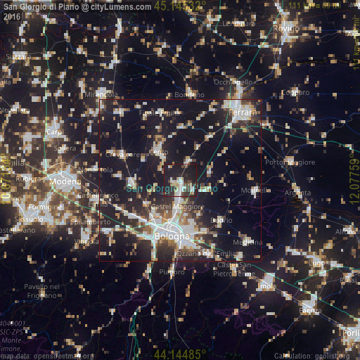
Analysis of San Giorgio di Piano night lights 2016
Square area 10x10 km:
 5.91%
5.91%90-99
9.55%80-89
3.48%70-79
2.58%60-69
2.27%50-59
2.88%40-49
4.85%30-39
8.64%20-29
21.52%10-19
38.03%0-9
0.3%Square area 50x50 km:
5.32%90-99
6.46%80-89
2.61%70-79
2.45%60-69
2.77%50-59
3.17%40-49
3.67%30-39
4.71%20-29
9.87%10-19
29.85%0-9
29.14%Clear (daylight) street map image can be seen on geolist.org.
Map coordinates:
45° 8' 43.2" North, 10° 40' 16.8" East
44° 38' 50.1" North, 11° 22' 28.1" East
44° 8' 41.5" North, 12° 4' 39.3" East
Some cities around San Giorgio di Piano sort by population:
• Cento
11.6 km =7.2 mi,  323°
323°
• Castel Maggiore
7.9 km =4.9 mi,  187°
187°
• Progresso
8.7 km =5.4 mi, 185°
• San Pietro in Casale
6.4 km =4 mi,  22°
22°
• Calderara di Reno
12.4 km =7.7 mi,  221°
221°
• Pieve di Cento
8.9 km =5.5 mi, 324°
• Granarolo dell'Emilia e Viadagola
11.8 km =7.3 mi,  152°
152°
• Decima
13.4 km =8.3 mi,  301°
301°
3168300 (p: 5,850)
Sources (retrieved 2019-11-25):
» Earth at Night: Flat Maps 2012, 2016