Montichiari night lights from space
Night Light of Montichiari (Lombardy) from space (Italy) Src. Average luminocity for 10x10km area is 46.0651% and for 50x50km: 38.5818%.
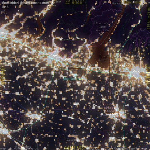
Analysis of Montichiari night lights 2016
Square area 10x10 km:
 5.71%
5.71%90-99
6.83%80-89
3.17%70-79
3.97%60-69
6.35%50-59
5.56%40-49
10.95%30-39
23.97%20-29
32.06%10-19
1.43%0-9
0%Square area 50x50 km:
6.24%90-99
7.58%80-89
2.93%70-79
3.56%60-69
4.95%50-59
5.52%40-49
6.17%30-39
8.08%20-29
14.13%10-19
30.29%0-9
10.57%Clear (daylight) street map image can be seen on geolist.org.
Map coordinates:
45° 54' 16.6" North, 9° 41' 41.5" East
45° 24' 47.4" North, 10° 23' 52.8" East
44° 55' 2.7" North, 11° 6' 4" East
Some cities around Montichiari sort by population:
• Castiglione delle Stiviere
7.3 km =4.5 mi,  110°
110°
• Ghedi
9.5 km =5.9 mi,  262°
262°
• Carpenedolo
6.3 km =3.9 mi,  155°
155°
• Calcinato
5 km =3.1 mi,  10°
10°
• Piazza
10.9 km =6.8 mi, 10°
• Molinetto
9.5 km =5.9 mi,  341°
341°
• Castenedolo
10.7 km =6.6 mi,  309°
309°
• Lonato
8.1 km =5 mi,  49°
49°
3172681 (p: 15,030)
Sources (retrieved 2019-11-25):
» Earth at Night: Flat Maps 2012, 2016