Molinetto night lights from space
Night Light of Molinetto (Lombardy) from space (Italy) Src. Average luminocity for 10x10km area is 63.5143% and for 50x50km: 38.3776%.
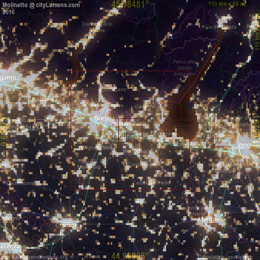
Analysis of Molinetto night lights 2016
Square area 10x10 km:
 12.86%
90-99
13.33%80-89
3.65%70-79
8.1%60-69
6.83%50-59
17.3%40-49
19.52%30-39
17.94%20-29
0.48%10-19
0%0-9
0%Square area 50x50 km:
6.28%90-99
7.35%80-89
2.88%70-79
3.93%60-69
5.3%50-59
5.67%40-49
6.26%30-39
8.01%20-29
14.23%10-19
24.37%0-9
15.71%Clear (daylight) street map image can be seen on geolist.org.
Map coordinates:
45° 59' 5.3" North, 9° 39' 20.7" East
45° 29' 38.7" North, 10° 21' 32" East
44° 59' 56.6" North, 11° 3' 43.2" East
Some cities around Molinetto sort by population:
• Rezzato
3.8 km =2.4 mi,  301°
301°
• Botticino
5.4 km =3.4 mi,  316°
316°
• Bedizzole
5.3 km =3.3 mi,  70°
70°
• Calcinato
5.7 km =3.5 mi,  135°
135°
• Borgosatollo
9.4 km =5.8 mi,  258°
258°
• Piazza
5.4 km =3.4 mi, 71°
• Castenedolo
5.7 km =3.5 mi,  247°
247°
• Prevalle
8.1 km =5 mi,  37°
37°
9036384 (p: 8,296)
Sources (retrieved 2019-11-25):
» Earth at Night: Flat Maps 2012, 2016