Castenedolo night lights from space
Night Light of Castenedolo (Lombardy) from space (Italy) Src. Average luminocity for 10x10km area is 66.4286% and for 50x50km: 40.9865%.
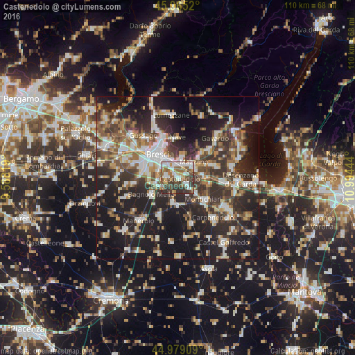
Analysis of Castenedolo night lights 2016
Square area 10x10 km:
 15.08%
90-99
18.1%80-89
3.65%70-79
6.67%60-69
9.37%50-59
14.13%40-49
12.54%30-39
15.08%20-29
5.4%10-19
0%0-9
0%Square area 50x50 km:
6.68%90-99
7.84%80-89
3.34%70-79
4.33%60-69
5.5%50-59
6.33%40-49
6.76%30-39
8.53%20-29
14.48%10-19
26.09%0-9
10.12%Clear (daylight) street map image can be seen on geolist.org.
Map coordinates:
45° 57' 54.7" North, 9° 35' 17.5" East
45° 28' 27.5" North, 10° 17' 28.7" East
44° 58' 44.7" North, 10° 59' 40" East
Some cities around Castenedolo sort by population:
• Brescia
9.1 km =5.7 mi,  318°
318°
• Ghedi
8.1 km =5 mi,  188°
188°
• Rezzato
4.6 km =2.9 mi,  25°
25°
• Botticino
6.3 km =3.9 mi,  13°
13°
• Calcinato
9.4 km =5.8 mi,  101°
101°
• Borgosatollo
4 km =2.5 mi,  274°
274°
• Molinetto
5.7 km =3.5 mi,  67°
67°
• Flero
9 km =5.6 mi,  275°
275°
3179440 (p: 8,264)
Sources (retrieved 2019-11-25):
» Earth at Night: Flat Maps 2012, 2016