Gavirate night lights from space
Night Light of Gavirate (Lombardy) from space (Italy) Src. Average luminocity for 10x10km area is 39.1577% and for 50x50km: 36.2609%.
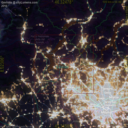
Analysis of Gavirate night lights 2016
Square area 10x10 km:
100  4.17%
4.17%
90-99 4.32%
80-89 3.57%
70-79 4.17%
60-69 4.46%
50-59 6.99%
40-49 6.55%
30-39 13.99%
20-29 29.91%
10-19 21.88%
0-9 0%
4.17%90-99
4.32%80-89
3.57%70-79
4.17%60-69
4.46%50-59
6.99%40-49
6.55%30-39
13.99%20-29
29.91%10-19
21.88%0-9
0%Square area 50x50 km:
100 5.18%
90-99 6.88%
80-89 3.47%
70-79 4.43%
60-69 5.98%
50-59 6.13%
40-49 6.1%
30-39 6.49%
20-29 8.6%
10-19 21.94%
0-9 24.8%
5.18%90-99
6.88%80-89
3.47%70-79
4.43%60-69
5.98%50-59
6.13%40-49
6.1%30-39
6.49%20-29
8.6%10-19
21.94%0-9
24.8%Clear (daylight) street map image can be seen on geolist.org.
Map coordinates:
46° 19' 29.2" North, 8° 1' 23" East
45° 50' 13.5" North, 8° 43' 34.3" East
45° 20' 42.2" North, 9° 25' 45.5" East
Some cities around Gavirate sort by population:
• Varese
7.9 km =4.9 mi,  103°
103°
• Malnate
12.9 km =8 mi,  111°
111°
• Induno Olona
8.9 km =5.5 mi,  83°
83°
• Besozzo
4.9 km =3 mi,  285°
285°
• Laveno
11.4 km =7.1 mi,  314°
314°
• Arcisate
11.2 km =7 mi, 79°
• Vergiate
13 km =8.1 mi,  190°
190°
• Sumirago
12 km =7.5 mi,  158°
158°
3176261 (p: 9,206)
Sources (retrieved 2019-11-25):
» Earth at Night: Flat Maps 2012, 2016