Laveno night lights from space
Night Light of Laveno (Lombardy) from space (Italy) Src. Average luminocity for 10x10km area is 26.631% and for 50x50km: 23.108%.
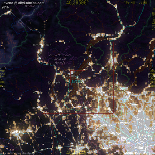
Analysis of Laveno night lights 2016
Square area 10x10 km:
 3.57%
3.57%90-99
4.61%80-89
1.04%70-79
0.74%60-69
2.53%50-59
5.06%40-49
4.17%30-39
7.44%20-29
5.06%10-19
44.05%0-9
21.73%Square area 50x50 km:
1.95%90-99
3.38%80-89
2.11%70-79
2.56%60-69
3.68%50-59
4.18%40-49
4.82%30-39
5.27%20-29
6.84%10-19
19.75%0-9
45.46%Clear (daylight) street map image can be seen on geolist.org.
Map coordinates:
46° 23' 45.5" North, 7° 55' 2.1" East
45° 54' 32" North, 8° 37' 13.3" East
45° 25' 3" North, 9° 19' 24.6" East
Some cities around Laveno sort by population:
• Verbania
5.5 km =3.4 mi,  284°
284°
• Pallanza-Intra-Suna
5 km =3.1 mi,  310°
310°
• Omegna
16.8 km =10.4 mi,  259°
259°
• Arona
17.4 km =10.8 mi,  196°
196°
• Luino
14.1 km =8.8 mi,  43°
43°
• Gavirate
11.4 km =7.1 mi,  134°
134°
• Besozzo
7.5 km =4.7 mi,  152°
152°
• Gravellona Toce
14.7 km =9.1 mi, 278°
3175003 (p: 8,130)
Sources (retrieved 2019-11-25):
» Earth at Night: Flat Maps 2012, 2016