Induno Olona night lights from space
Night Light of Induno Olona (Lombardy) from space (Italy) Src. Average luminocity for 10x10km area is 52.0372% and for 50x50km: 39.0609%.
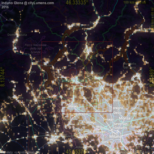
Analysis of Induno Olona night lights 2016
Square area 10x10 km:
 7.59%
7.59%90-99
12.2%80-89
3.57%70-79
8.18%60-69
6.7%50-59
7.44%40-49
9.82%30-39
12.35%20-29
17.56%10-19
14.58%0-9
0%Square area 50x50 km:
6.81%90-99
8.09%80-89
3.98%70-79
4.97%60-69
6.15%50-59
5.98%40-49
5.91%30-39
6.31%20-29
7.79%10-19
18.58%0-9
25.43%Clear (daylight) street map image can be seen on geolist.org.
Map coordinates:
46° 20' 0.1" North, 8° 8' 14.8" East
45° 50' 44.6" North, 8° 50' 26" East
45° 21' 13.5" North, 9° 32' 37.3" East
Some cities around Induno Olona sort by population:
• Varese
3 km =1.9 mi,  203°
203°
• Malnate
6.6 km =4.1 mi,  151°
151°
• Gavirate
8.9 km =5.5 mi,  263°
263°
• Arcisate
2.4 km =1.5 mi,  62°
62°
• Mendrisio, CH
11.3 km =7 mi,  76°
76°
• Castiglione Olona
10.7 km =6.6 mi,  166°
166°
• Vedano Olona
8.6 km =5.3 mi, 154°
• Venegono Superiore
11.3 km =7 mi,  156°
156°
3175521 (p: 10,258)
Sources (retrieved 2019-11-25):
» Earth at Night: Flat Maps 2012, 2016