Arcisate night lights from space
Night Light of Arcisate (Lombardy) from space (Italy) Src. Average luminocity for 10x10km area is 47.0744% and for 50x50km: 38.5982%.
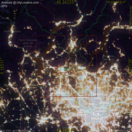
Analysis of Arcisate night lights 2016
Square area 10x10 km:
 5.95%
5.95%90-99
8.33%80-89
2.83%70-79
7.14%60-69
6.7%50-59
6.1%40-49
13.69%30-39
13.1%20-29
18.15%10-19
18.01%0-9
0%Square area 50x50 km:
7.02%90-99
8.04%80-89
3.95%70-79
4.83%60-69
6%50-59
5.84%40-49
5.87%30-39
6.09%20-29
7.52%10-19
17.25%0-9
27.6%Clear (daylight) street map image can be seen on geolist.org.
Map coordinates:
46° 20' 36" North, 8° 9' 54.4" East
45° 51' 20.8" North, 8° 52' 5.6" East
45° 21' 50.1" North, 9° 34' 16.9" East
Some cities around Arcisate sort by population:
• Varese
5.1 km =3.2 mi,  220°
220°
• Malnate
7 km =4.3 mi,  171°
171°
• Olgiate Comasco
11.1 km =6.9 mi,  135°
135°
• Induno Olona
2.4 km =1.5 mi,  242°
242°
• Gavirate
11.2 km =7 mi,  259°
259°
• Mendrisio, CH
8.9 km =5.5 mi,  79°
79°
• Castiglione Olona
11.5 km =7.1 mi,  178°
178°
• Vedano Olona
9 km =5.6 mi, 170°
6534244 (p: 7,645)
Sources (retrieved 2019-11-25):
» Earth at Night: Flat Maps 2012, 2016