Castelnuovo Rangone night lights from space
Night Light of Castelnuovo Rangone (Emilia-Romagna) from space (Italy) Src. Average luminocity for 10x10km area is 54.5413% and for 50x50km: 31.423%.
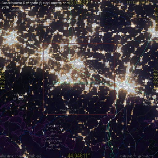
Analysis of Castelnuovo Rangone night lights 2016
Square area 10x10 km:
 5.4%
5.4%90-99
9.68%80-89
5.08%70-79
6.35%60-69
4.6%50-59
17.46%40-49
22.22%30-39
12.06%20-29
17.14%10-19
0%0-9
0%Square area 50x50 km:
5.15%90-99
6.5%80-89
2.85%70-79
2.63%60-69
3.17%50-59
4.12%40-49
5.96%30-39
6.94%20-29
12.49%10-19
17.5%0-9
32.7%Clear (daylight) street map image can be seen on geolist.org.
Map coordinates:
45° 2' 53.8" North, 10° 13' 49.4" East
44° 32' 57.7" North, 10° 56' 0.6" East
44° 2' 46" North, 11° 38' 11.9" East
Some cities around Castelnuovo Rangone sort by population:
• Modena
11 km =6.8 mi,  356°
356°
• Sassuolo
11.8 km =7.3 mi,  266°
266°
• Formigine
7.3 km =4.5 mi,  290°
290°
• Vignola
9.5 km =5.9 mi,  139°
139°
• Fiorano
9.7 km =6 mi,  263°
263°
• Maranello
5.5 km =3.4 mi,  248°
248°
• Spilamberto
6.9 km =4.3 mi,  105°
105°
• Bazzano
13.3 km =8.3 mi, 113°
3179514 (p: 8,064)
Sources (retrieved 2019-11-25):
» Earth at Night: Flat Maps 2012, 2016