Fiorano night lights from space
Night Light of Fiorano (Emilia-Romagna) from space (Italy) Src. Average luminocity for 10x10km area is 69.0778% and for 50x50km: 29.784%.
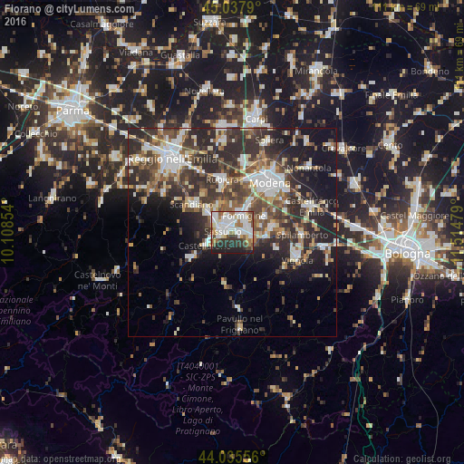
Analysis of Fiorano night lights 2016
Square area 10x10 km:
 24.13%
90-99
20.95%80-89
5.4%70-79
2.54%60-69
8.73%50-59
5.87%40-49
6.19%30-39
6.83%20-29
14.13%10-19
5.24%0-9
0%Square area 50x50 km:
4.89%90-99
6.06%80-89
2.95%70-79
2.71%60-69
3.23%50-59
4.15%40-49
5.82%30-39
6.85%20-29
11.53%10-19
12.07%0-9
39.74%Clear (daylight) street map image can be seen on geolist.org.
Map coordinates:
45° 2' 16.4" North, 10° 6' 30.7" East
44° 32' 20" North, 10° 48' 42" East
44° 2' 8" North, 11° 30' 53.2" East
Some cities around Fiorano sort by population:
• Sassuolo
2.2 km =1.4 mi,  282°
282°
• Formigine
4.7 km =2.9 mi,  36°
36°
• Scandiano
11.3 km =7 mi,  305°
305°
• Castellarano
6.3 km =3.9 mi,  248°
248°
• Maranello
4.6 km =2.9 mi,  100°
100°
• Castelnuovo Rangone
9.7 km =6 mi,  83°
83°
• Casalgrande
7.9 km =4.9 mi, 310°
• Veggia-Villalunga
5 km =3.1 mi,  298°
298°
3176970 (p: 16,278)
Sources (retrieved 2019-11-25):
» Earth at Night: Flat Maps 2012, 2016