Maranello night lights from space
Night Light of Maranello (Emilia-Romagna) from space (Italy) Src. Average luminocity for 10x10km area is 57.9603% and for 50x50km: 29.5389%.
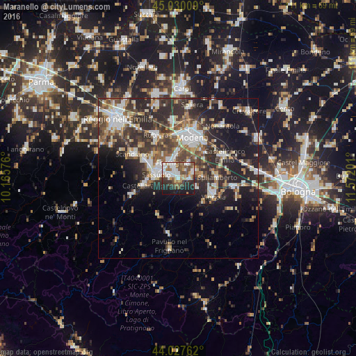
Analysis of Maranello night lights 2016
Square area 10x10 km:
 14.76%
90-99
13.81%80-89
4.13%70-79
4.76%60-69
7.94%50-59
10.16%40-49
10%30-39
6.98%20-29
13.33%10-19
14.13%0-9
0%Square area 50x50 km:
4.92%90-99
6.05%80-89
2.76%70-79
2.54%60-69
3.31%50-59
4.18%40-49
5.63%30-39
6.43%20-29
10.97%10-19
14.26%0-9
38.95%Clear (daylight) street map image can be seen on geolist.org.
Map coordinates:
45° 1' 48.3" North, 10° 9' 56.7" East
44° 31' 51.6" North, 10° 52' 8" East
44° 1' 39.4" North, 11° 34' 19.2" East
Some cities around Maranello sort by population:
• Sassuolo
6.8 km =4.2 mi,  281°
281°
• Formigine
4.9 km =3 mi,  339°
339°
• Fiorano
4.6 km =2.9 mi, 280°
• Castellarano
10.5 km =6.5 mi,  262°
262°
• Spilamberto
11.7 km =7.3 mi,  89°
89°
• Castelnuovo Rangone
5.5 km =3.4 mi,  68°
68°
• Casalgrande
12.1 km =7.5 mi,  299°
299°
• Veggia-Villalunga
9.5 km =5.9 mi,  290°
290°
3174032 (p: 9,228)
Sources (retrieved 2019-11-25):
» Earth at Night: Flat Maps 2012, 2016