Molinella night lights from space
Night Light of Molinella (Emilia-Romagna) from space (Italy) Src. Average luminocity for 10x10km area is 11.7424% and for 50x50km: 21.5708%.
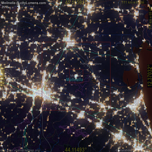
Analysis of Molinella night lights 2016
Square area 10x10 km:
 2.42%
2.42%90-99
2.42%80-89
0.45%70-79
0.15%60-69
1.06%50-59
2.58%40-49
0.61%30-39
2.42%20-29
0.15%10-19
0.61%0-9
87.12%Square area 50x50 km:
3.25%90-99
4.33%80-89
1.83%70-79
2.05%60-69
2.2%50-59
2.44%40-49
2.58%30-39
2.85%20-29
6.04%10-19
19.6%0-9
52.83%Clear (daylight) street map image can be seen on geolist.org.
Map coordinates:
45° 6' 57.3" North, 10° 57' 50.7" East
44° 37' 3.3" North, 11° 40' 1.9" East
44° 6' 53.7" North, 12° 22' 13.2" East
Some cities around Molinella sort by population:
• Massa Lombarda
22.5 km =14 mi,  147°
147°
• Castenaso
19.5 km =12.1 mi,  233°
233°
• Budrio
13.8 km =8.6 mi, 229°
• Medicina-Buda
15.6 km =9.7 mi,  188°
188°
• Portomaggiore
14.2 km =8.8 mi,  51°
51°
• Argenta
13.3 km =8.3 mi,  91°
91°
• Granarolo dell'Emilia e Viadagola
19.1 km =11.9 mi,  248°
248°
• Poggio Renatico
21.8 km =13.5 mi,  319°
319°
3173276 (p: 9,377)
Sources (retrieved 2019-11-25):
» Earth at Night: Flat Maps 2012, 2016