Broni night lights from space
Night Light of Broni (Lombardy) from space (Italy) Src. Average luminocity for 10x10km area is 33.3879% and for 50x50km: 19.5872%.
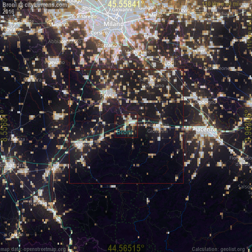
Analysis of Broni night lights 2016
Square area 10x10 km:
 3.48%
3.48%90-99
7.88%80-89
4.55%70-79
2.58%60-69
3.64%50-59
5.3%40-49
3.48%30-39
2.12%20-29
13.94%10-19
31.36%0-9
21.67%Square area 50x50 km:
1.89%90-99
3.08%80-89
2.21%70-79
1.79%60-69
2.31%50-59
2.13%40-49
2.1%30-39
2.75%20-29
7.46%10-19
27.96%0-9
46.31%Clear (daylight) street map image can be seen on geolist.org.
Map coordinates:
45° 33' 30.3" North, 8° 33' 24.5" East
45° 3' 50.2" North, 9° 15' 35.7" East
44° 33' 54.5" North, 9° 57' 47" East
Some cities around Broni sort by population:
• Pavia
16.3 km =10.1 mi,  330°
330°
• Voghera
21.1 km =13.1 mi,  247°
247°
• Solaro
21.6 km =13.4 mi,  198°
198°
• Castel San Giovanni
14 km =8.7 mi,  91°
91°
• Stradella
3.5 km =2.2 mi,  70°
70°
• Casteggio
12 km =7.5 mi,  242°
242°
• Belgioioso
11.4 km =7.1 mi,  21°
21°
• Borgonovo Valtidone
15.4 km =9.6 mi,  110°
110°
3181507 (p: 8,420)
Sources (retrieved 2019-11-25):
» Earth at Night: Flat Maps 2012, 2016