Stradella night lights from space
Night Light of Stradella (Lombardy) from space (Italy) Src. Average luminocity for 10x10km area is 36.1% and for 50x50km: 21.2235%.
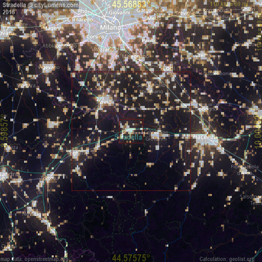
Analysis of Stradella night lights 2016
Square area 10x10 km:
 3.79%
3.79%90-99
8.48%80-89
4.55%70-79
3.03%60-69
4.24%50-59
4.7%40-49
2.58%30-39
4.39%20-29
14.24%10-19
45.15%0-9
4.85%Square area 50x50 km:
2.18%90-99
3.43%80-89
2.27%70-79
1.88%60-69
2.54%50-59
2.28%40-49
2.3%30-39
2.94%20-29
8.84%10-19
30.03%0-9
41.31%Clear (daylight) street map image can be seen on geolist.org.
Map coordinates:
45° 34' 7.8" North, 8° 35' 54.9" East
45° 4' 28" North, 9° 18' 6.1" East
44° 34' 32.7" North, 10° 0' 17.4" East
Some cities around Stradella sort by population:
• Pavia
17.2 km =10.7 mi,  319°
319°
• Sant'Angelo Lodigiano
19.7 km =12.2 mi,  24°
24°
• Castel San Giovanni
10.8 km =6.7 mi,  98°
98°
• Broni
3.5 km =2.2 mi,  250°
250°
• San Colombano al Lambro
19.1 km =11.9 mi,  50°
50°
• Casteggio
15.4 km =9.6 mi,  244°
244°
• Belgioioso
9.5 km =5.9 mi,  5°
5°
• Borgonovo Valtidone
13 km =8.1 mi,  120°
120°
3166114 (p: 10,785)
Sources (retrieved 2019-11-25):
» Earth at Night: Flat Maps 2012, 2016