Belgioioso night lights from space
Night Light of Belgioioso (Lombardy) from space (Italy) Src. Average luminocity for 10x10km area is 25.5455% and for 50x50km: 29.7462%.
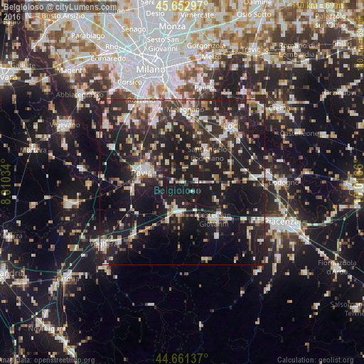
Analysis of Belgioioso night lights 2016
Square area 10x10 km:
 1.52%
1.52%90-99
3.64%80-89
3.79%70-79
1.21%60-69
2.27%50-59
1.67%40-49
4.09%30-39
2.73%20-29
3.33%10-19
75.15%0-9
0.61%Square area 50x50 km:
3.61%90-99
5.17%80-89
3.19%70-79
2.8%60-69
3.63%50-59
3.23%40-49
3.6%30-39
5.22%20-29
14.26%10-19
31.54%0-9
23.74%Clear (daylight) street map image can be seen on geolist.org.
Map coordinates:
45° 39' 10.7" North, 8° 36' 37.2" East
45° 9' 33.6" North, 9° 18' 48.5" East
44° 39' 40.9" North, 10° 0' 59.8" East
Some cities around Belgioioso sort by population:
• Pavia
12.6 km =7.8 mi,  286°
286°
• Sant'Angelo Lodigiano
11.2 km =7 mi,  40°
40°
• Castel San Giovanni
14.7 km =9.1 mi,  138°
138°
• Stradella
9.5 km =5.9 mi,  185°
185°
• Broni
11.4 km =7.1 mi,  201°
201°
• Lodi Vecchio
18.1 km =11.2 mi,  26°
26°
• San Colombano al Lambro
14.1 km =8.8 mi,  79°
79°
• Borgonovo Valtidone
19.1 km =11.9 mi,  147°
147°
3182237 (p: 6,209)
Sources (retrieved 2019-11-25):
» Earth at Night: Flat Maps 2012, 2016