Borgonovo Valtidone night lights from space
Night Light of Borgonovo Valtidone (Emilia-Romagna) from space (Italy) Src. Average luminocity for 10x10km area is 15.5397% and for 50x50km: 19.8953%.
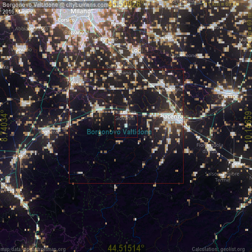
Analysis of Borgonovo Valtidone night lights 2016
Square area 10x10 km:
 0.79%
0.79%90-99
2.86%80-89
0.32%70-79
1.59%60-69
1.75%50-59
1.75%40-49
1.11%30-39
2.06%20-29
2.38%10-19
30.48%0-9
54.92%Square area 50x50 km:
2.57%90-99
3.78%80-89
2.07%70-79
1.76%60-69
1.98%50-59
2.08%40-49
2.18%30-39
2.95%20-29
7.52%10-19
24.75%0-9
48.37%Clear (daylight) street map image can be seen on geolist.org.
Map coordinates:
45° 30' 33.3" North, 8° 44' 25.2" East
45° 0' 51.7" North, 9° 26' 36.5" East
44° 30' 54.5" North, 10° 8' 47.7" East
Some cities around Borgonovo Valtidone sort by population:
• Piacenza
20.1 km =12.5 mi,  77°
77°
• Castel San Giovanni
5.1 km =3.2 mi,  355°
355°
• Stradella
13 km =8.1 mi,  300°
300°
• San Nicolò
13.6 km =8.5 mi,  69°
69°
• Broni
15.4 km =9.6 mi,  290°
290°
• San Colombano al Lambro
19.1 km =11.9 mi,  11°
11°
• Belgioioso
19.1 km =11.9 mi,  327°
327°
• Podenzano
20 km =12.4 mi,  109°
109°
3181779 (p: 5,777)
Sources (retrieved 2019-11-25):
» Earth at Night: Flat Maps 2012, 2016