Vaprio d'Adda night lights from space
Night Light of Vaprio d'Adda (Lombardy) from space (Italy) Src. Average luminocity for 10x10km area is 77.7591% and for 50x50km: 65.3844%.
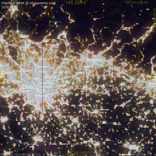
Analysis of Vaprio d'Adda night lights 2016
Square area 10x10 km:
 16.97%
90-99
21.36%80-89
7.12%70-79
16.21%60-69
19.55%50-59
11.52%40-49
7.27%30-39
0%20-29
0%10-19
0%0-9
0%Square area 50x50 km:
19.65%90-99
15.9%80-89
6.18%70-79
7.74%60-69
8.97%50-59
7.36%40-49
6.76%30-39
7.8%20-29
11.03%10-19
7.17%0-9
1.42%Clear (daylight) street map image can be seen on geolist.org.
Map coordinates:
46° 3' 59" North, 8° 49' 15.4" East
45° 34' 35" North, 9° 31' 26.7" East
45° 4' 55.5" North, 10° 13' 37.9" East
Some cities around Vaprio d'Adda sort by population:
• Cassano d'Adda
5.6 km =3.5 mi,  187°
187°
• Trezzo sull'Adda
3.3 km =2.1 mi,  346°
346°
• Inzago
5.1 km =3.2 mi,  217°
217°
• Capriate San Gervasio
4.1 km =2.5 mi,  6°
6°
• Fara Gera d'Adda
2.4 km =1.5 mi,  156°
156°
• Brembate
4 km =2.5 mi,  37°
37°
• Ciserano
6.1 km =3.8 mi,  77°
77°
• Boltiere
5 km =3.1 mi,  57°
57°
3164723 (p: 7,901)
Sources (retrieved 2019-11-25):
» Earth at Night: Flat Maps 2012, 2016