Torbole Casaglia night lights from space
Night Light of Torbole Casaglia (Lombardy) from space (Italy) Src. Average luminocity for 10x10km area is 73.727% and for 50x50km: 40.5497%.
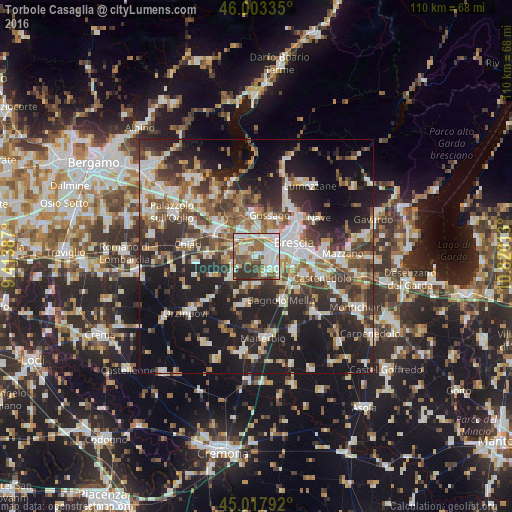
Analysis of Torbole Casaglia night lights 2016
Square area 10x10 km:
 21.59%
90-99
20.95%80-89
6.35%70-79
6.03%60-69
11.75%50-59
12.22%40-49
6.19%30-39
13.02%20-29
1.9%10-19
0%0-9
0%Square area 50x50 km:
6.98%90-99
8.23%80-89
3.47%70-79
3.77%60-69
5.4%50-59
6.69%40-49
6.23%30-39
7.71%20-29
12.99%10-19
23.35%0-9
15.17%Clear (daylight) street map image can be seen on geolist.org.
Map coordinates:
46° 0' 12.1" North, 9° 24' 49.9" East
45° 30' 46" North, 10° 7' 1.2" East
45° 1' 4.5" North, 10° 49' 12.5" East
Some cities around Torbole Casaglia sort by population:
• Brescia
8 km =5 mi,  71°
71°
• Gussago
8.5 km =5.3 mi,  21°
21°
• Ospitaletto
5.4 km =3.4 mi,  323°
323°
• Travagliato
3.1 km =1.9 mi,  293°
293°
• Castel Mella
2.7 km =1.7 mi,  124°
124°
• Roncadelle
3.3 km =2.1 mi,  61°
61°
• Castegnato
5.4 km =3.4 mi,  357°
357°
• Flero
5.8 km =3.6 mi,  125°
125°
3165542 (p: 6,174)
Sources (retrieved 2019-11-25):
» Earth at Night: Flat Maps 2012, 2016