Artena night lights from space
Night Light of Artena (Latium) from space (Italy) Src. Average luminocity for 10x10km area is 36.4253% and for 50x50km: 34.107%.
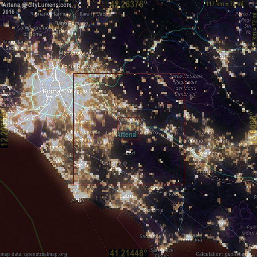
Analysis of Artena night lights 2016
Square area 10x10 km:
100  1.79%
1.79%
90-99 3.73%
80-89 5.19%
70-79 5.19%
60-69 5.03%
50-59 4.71%
40-49 10.39%
30-39 6.82%
20-29 20.78%
10-19 32.95%
0-9 3.41%
1.79%90-99
3.73%80-89
5.19%70-79
5.19%60-69
5.03%50-59
4.71%40-49
10.39%30-39
6.82%20-29
20.78%10-19
32.95%0-9
3.41%Square area 50x50 km:
100 4.45%
90-99 6.15%
80-89 4%
70-79 4.64%
60-69 4.96%
50-59 6.02%
40-49 5.57%
30-39 5.66%
20-29 9.66%
10-19 16.79%
0-9 32.09%
4.45%90-99
6.15%80-89
4%70-79
4.64%60-69
4.96%50-59
6.02%40-49
5.57%30-39
5.66%20-29
9.66%10-19
16.79%0-9
32.09%Clear (daylight) street map image can be seen on geolist.org.
Map coordinates:
42° 15' 49.5" North, 12° 12' 12.8" East
41° 44' 28.5" North, 12° 54' 24" East
41° 12' 52.1" North, 13° 36' 35.3" East
Some cities around Artena sort by population:
• Colleferro
8.3 km =5.2 mi,  100°
100°
• Palestrina
10.4 km =6.5 mi,  348°
348°
• Valmontone
3.7 km =2.3 mi,  15°
15°
• Lariano
7 km =4.3 mi,  248°
248°
• Rocca Priora
12 km =7.5 mi,  283°
283°
• Cave
8.9 km =5.5 mi, 18°
• Segni
11 km =6.8 mi,  121°
121°
• Cori
10.9 km =6.8 mi,  178°
178°
3182778 (p: 10,805)
Sources (retrieved 2019-11-25):
» Earth at Night: Flat Maps 2012, 2016