Palestrina night lights from space
Night Light of Palestrina (Latium) from space (Italy) Src. Average luminocity for 10x10km area is 47.4587% and for 50x50km: 35.5898%.
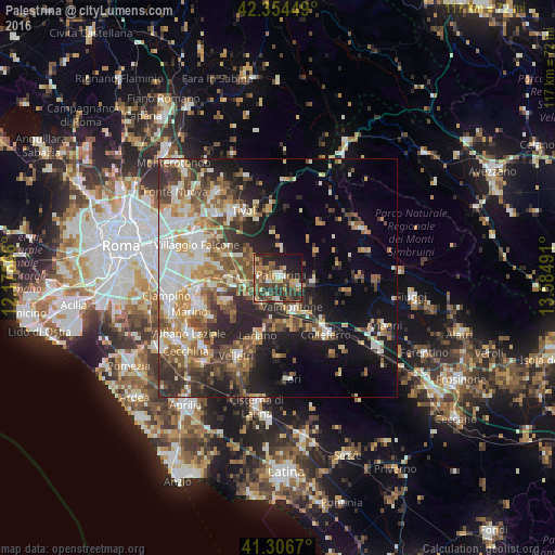
Analysis of Palestrina night lights 2016
Square area 10x10 km:
 3.33%
3.33%90-99
6.35%80-89
5.08%70-79
7.62%60-69
9.84%50-59
9.68%40-49
13.02%30-39
14.13%20-29
14.6%10-19
15.08%0-9
1.27%Square area 50x50 km:
5.54%90-99
6.87%80-89
4.14%70-79
4.62%60-69
4.92%50-59
6.07%40-49
6.07%30-39
5.61%20-29
8.92%10-19
12.91%0-9
34.32%Clear (daylight) street map image can be seen on geolist.org.
Map coordinates:
42° 21' 16.2" North, 12° 10' 43.2" East
41° 49' 57.9" North, 12° 52' 54.4" East
41° 18' 24.1" North, 13° 35' 5.7" East
Some cities around Palestrina sort by population:
• Valmontone
7.3 km =4.5 mi,  155°
155°
• Zagarolo
5.6 km =3.5 mi,  280°
280°
• Artena
10.4 km =6.5 mi,  168°
168°
• San Cesareo
6.5 km =4 mi,  258°
258°
• Rocca Priora
12.2 km =7.6 mi,  232°
232°
• Cave
5.2 km =3.2 mi,  109°
109°
• Montecompatri
12.2 km =7.6 mi, 257°
• Olevano Romano
13.1 km =8.1 mi,  77°
77°
3171606 (p: 14,925)
Sources (retrieved 2019-11-25):
» Earth at Night: Flat Maps 2012, 2016