Cori night lights from space
Night Light of Cori (Latium) from space (Italy) Src. Average luminocity for 10x10km area is 11.4481% and for 50x50km: 34.3927%.
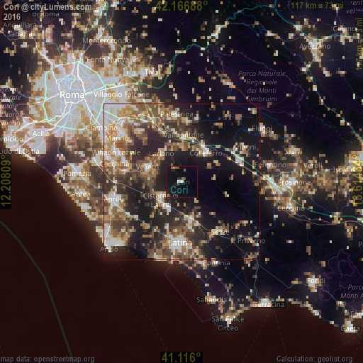
Analysis of Cori night lights 2016
Square area 10x10 km:
 0.32%
0.32%90-99
1.62%80-89
0.65%70-79
0%60-69
1.46%50-59
1.79%40-49
1.3%30-39
0.65%20-29
3.41%10-19
18.02%0-9
70.78%Square area 50x50 km:
3.81%90-99
5.47%80-89
4.15%70-79
4.27%60-69
5.1%50-59
6.77%40-49
6.67%30-39
6.42%20-29
10.55%10-19
19.68%0-9
27.12%Clear (daylight) street map image can be seen on geolist.org.
Map coordinates:
42° 10' 0.8" North, 12° 12' 29.1" East
41° 38' 36.9" North, 12° 54' 40.4" East
41° 6' 57.6" North, 13° 36' 51.6" East
Some cities around Cori sort by population:
• Velletri
12.1 km =7.5 mi,  292°
292°
• Cisterna di Latina
9.1 km =5.7 mi,  229°
229°
• Colleferro
12.1 km =7.5 mi,  39°
39°
• Valmontone
14.4 km =8.9 mi,  2°
2°
• Lariano
10.8 km =6.7 mi,  320°
320°
• Artena
10.9 km =6.8 mi,  358°
358°
• Latina Scalo
12.8 km =8 mi,  167°
167°
• Segni
10.3 km =6.4 mi,  60°
60°
3178099 (p: 6,376)
Sources (retrieved 2019-11-25):
» Earth at Night: Flat Maps 2012, 2016