Lariano night lights from space
Night Light of Lariano (Latium) from space (Italy) Src. Average luminocity for 10x10km area is 39.3052% and for 50x50km: 41.3446%.
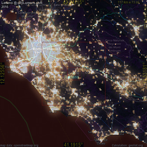
Analysis of Lariano night lights 2016
Square area 10x10 km:
 2.27%
2.27%90-99
4.87%80-89
3.25%70-79
6.66%60-69
6.01%50-59
8.28%40-49
9.58%30-39
5.68%20-29
24.19%10-19
28.9%0-9
0.32%Square area 50x50 km:
7.23%90-99
7.43%80-89
4.63%70-79
5.24%60-69
5.88%50-59
7.21%40-49
7.21%30-39
7.43%20-29
10.42%10-19
15.24%0-9
22.09%Clear (daylight) street map image can be seen on geolist.org.
Map coordinates:
42° 14' 28.1" North, 12° 7' 32" East
41° 43' 6.5" North, 12° 49' 43.2" East
41° 11' 29.4" North, 13° 31' 54.5" East
Some cities around Lariano sort by population:
• Velletri
5.6 km =3.5 mi,  229°
229°
• Genzano di Roma
11.7 km =7.3 mi,  263°
263°
• Rocca di Papa
11.8 km =7.3 mi,  296°
296°
• Valmontone
9.6 km =6 mi,  50°
50°
• Artena
7 km =4.3 mi,  68°
68°
• San Cesareo
11.6 km =7.2 mi,  350°
350°
• Rocca Priora
7.4 km =4.6 mi,  315°
315°
• Cori
10.8 km =6.7 mi,  140°
140°
3175106 (p: 12,893)
Sources (retrieved 2019-11-25):
» Earth at Night: Flat Maps 2012, 2016