Rāmshīr night lights from space
Night Light of Rāmshīr (Khuzestan) from space (Iran) Src. Average luminocity for 10x10km area is 22.4073% and for 50x50km: 29.755%.
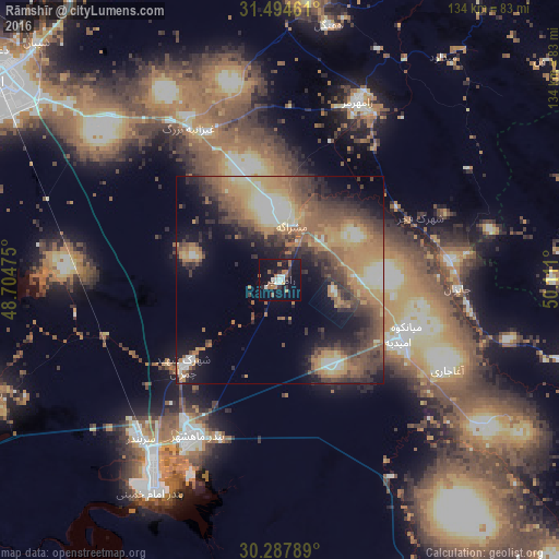
Analysis of Rāmshīr night lights 2016
Square area 10x10 km:
 2.97%
2.97%90-99
3.32%80-89
0%70-79
0.7%60-69
5.42%50-59
5.42%40-49
0.35%30-39
4.02%20-29
3.5%10-19
33.22%0-9
41.08%Square area 50x50 km:
2.04%90-99
3.48%80-89
3.98%70-79
6.08%60-69
6.47%50-59
6.56%40-49
5.72%30-39
6.39%20-29
6.01%10-19
11%0-9
42.27%Clear (daylight) street map image can be seen on geolist.org.
Map coordinates:
31° 29' 40.6" North, 48° 42' 17.1" East
30° 53' 35.3" North, 49° 24' 28.3" East
30° 17' 16.4" North, 50° 6' 39.6" East
Some cities around Rāmshīr sort by population:
• Ahvaz
83.6 km =51.9 mi,  304°
304°
• Masjed Soleymān
116.4 km =72.3 mi,  355°
355°
• Behbahān
86.3 km =53.6 mi,  112°
112°
• Dehdasht
111 km =69 mi,  95°
95°
• Omīdīyeh
31.6 km =19.6 mi,  117°
117°
• Rāmhormoz
46.9 km =29.1 mi,  23°
23°
• Shādegān
76 km =47.2 mi,  249°
249°
• Aghajari
45.8 km =28.5 mi, 117°
118805 (p: 19,454)
Sources (retrieved 2019-11-25):
» Earth at Night: Flat Maps 2012, 2016