Vadlapūdi night lights from space
Night Light of Vadlapūdi (Andhra Pradesh) from space (India) Src. Average luminocity for 10x10km area is 2.816% and for 50x50km: 13.6645%.
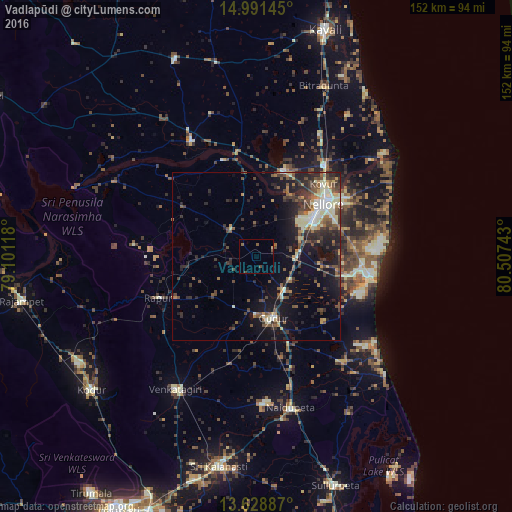
Analysis of Vadlapūdi night lights 2016
Square area 10x10 km:
 0%
0%90-99
0%80-89
0.43%70-79
0%60-69
0%50-59
1.95%40-49
1.52%30-39
0%20-29
0%10-19
0.43%0-9
95.67%Square area 50x50 km:
0.61%90-99
2.37%80-89
1.87%70-79
1.12%60-69
1.26%50-59
2.5%40-49
3.2%30-39
3.35%20-29
4.71%10-19
9.55%0-9
69.44%Clear (daylight) street map image can be seen on geolist.org.
Map coordinates:
14° 59' 29.2" North, 79° 6' 4.2" East
14° 18' 40.3" North, 79° 48' 15.5" East
13° 37' 43.9" North, 80° 30' 26.7" East
Some cities around Vadlapūdi sort by population:
• Nellore
25 km =15.5 mi,  51°
51°
• Kāvali
70.3 km =43.7 mi,  16°
16°
• Gūdūr
18.5 km =11.5 mi,  163°
163°
• Nāyudupet
45.9 km =28.5 mi,  167°
167°
• Sūlūru
71.7 km =44.6 mi, 161°
• Kovūr
28.7 km =17.8 mi,  42°
42°
• Venkatagiri
45.9 km =28.5 mi,  211°
211°
• Rāzampeta
70.7 km =43.9 mi,  259°
259°
1253578 (p: 17,881)
Sources (retrieved 2019-11-25):
» Earth at Night: Flat Maps 2012, 2016