Uttarkāshi night lights from space
Night Light of Uttarkāshi (Uttarakhand) from space (India) Src. Average luminocity for 10x10km area is 14.4143% and for 50x50km: 1.8932%.
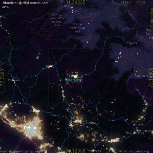
Analysis of Uttarkāshi night lights 2016
Square area 10x10 km:
 1.4%
1.4%90-99
2.1%80-89
2.8%70-79
0.7%60-69
2.1%50-59
1.4%40-49
2.8%30-39
1.92%20-29
2.27%10-19
1.92%0-9
80.59%Square area 50x50 km:
0.09%90-99
0.21%80-89
0.12%70-79
0.06%60-69
0.18%50-59
0.37%40-49
0.5%30-39
0.54%20-29
1.14%10-19
0.56%0-9
96.25%Clear (daylight) street map image can be seen on geolist.org.
Map coordinates:
31° 19' 56.5" North, 77° 44' 25.1" East
30° 43' 47.5" North, 78° 26' 36.3" East
30° 7' 24.9" North, 79° 8' 47.6" East
Some cities around Uttarkāshi sort by population:
• Dehra Dūn
59.8 km =37.2 mi,  221°
221°
• Rāipur
57.6 km =35.8 mi, 216°
• Tehri
37.9 km =23.5 mi,  174°
174°
• Mussoorie
47 km =29.2 mi,  229°
229°
• Clement Town
66.5 km =41.3 mi, 218°
• Srīnagar
65.2 km =40.5 mi,  149°
149°
• Doiwāla
69 km =42.9 mi,  206°
206°
• Barkot
24.3 km =15.1 mi,  291°
291°
1253628 (p: 17,123)
Sources (retrieved 2019-11-25):
» Earth at Night: Flat Maps 2012, 2016