Srīnagar night lights from space
Night Light of Srīnagar (Uttarakhand) from space (India) Src. Average luminocity for 10x10km area is 30.5052% and for 50x50km: 4.9395%.

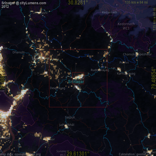
Analysis of Srīnagar night lights 2016
Square area 10x10 km:
 3.15%
3.15%90-99
6.47%80-89
5.94%70-79
4.02%60-69
1.05%50-59
1.05%40-49
1.4%30-39
3.5%20-29
9.27%10-19
51.4%0-9
12.76%Square area 50x50 km:
0.22%90-99
0.47%80-89
0.39%70-79
0.25%60-69
0.26%50-59
0.71%40-49
1.23%30-39
1.48%20-29
2.42%10-19
4.42%0-9
88.15%Clear (daylight) street map image can be seen on geolist.org.
Map coordinates:
30° 49' 41.2" North, 78° 4' 49" East
30° 13' 20.7" North, 78° 47' 0.3" East
29° 36' 46.8" North, 79° 29' 11.5" East
Some cities around Srīnagar sort by population:
• Rishīkesh
48.9 km =30.4 mi,  254°
254°
• Tehri
34.6 km =21.5 mi,  302°
302°
• Kotdwāra
58.6 km =36.4 mi,  205°
205°
• Pauri
7.8 km =4.8 mi,  184°
184°
• Birbhaddar
51.1 km =31.8 mi, 250°
• Doiwāla
64.3 km =40 mi,  265°
265°
• Lansdowne
43.5 km =27 mi,  193°
193°
• Rāīwāla Bara
57.9 km =36 mi, 246°
1255635 (p: 20,216)
Sources (retrieved 2019-11-25):
» Earth at Night: Flat Maps 2012, 2016